Where’s Sara?
Tiger Mountain – As Tony would say “A Grrrrreat Place to Explore”
Trying to find a hike these days where not too many people are going takes some extra time and creativity. I didn’t want to drive far but wanted to hike a ‘mountain’ so I decided to explore a little more Tiger Mountain in Issaquah. It is the closest mountain, only a 30 minute drive from Woodinville. There are over 70 miles of trails with 3 summits waiting to explore.
I have hiked Poo Poo Point many times and done West Tiger Summit 3 and the Chirico trail also. Everyone should know about these popular tourist trails on Tiger Mountain. But this time I wanted to find something NEW.
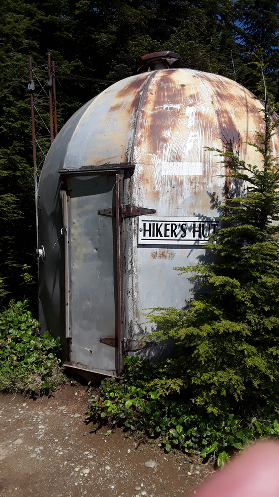
I took out my Tiger Mountain Green Trails Map (I highly recommend you buy one if you don’t have one at greentrailsmaps.com) I felt like a pirate looking for treasure as I laid my map on the kitchen table to carefully examine the trails. I located Tiger Summit 1,2 and 3 and then noticed in miniscule letters “Hikers Hut” next to Tiger Summit 1. AHA “X” marks the spot – something NEW waiting to be explored. I had never hiked to summit 1 or 2 and I had never heard of the “Hikers Hut.” I planned my adventure and set out to achieve all three summits and find the elusive hikers hut.
I chose the next sunny day and lucked out finding a parking place in the lot for Tiger Mt. located off I90 at Exit 19 for the Highpoint trailhead. It can get crowded on the weekend so plan accordingly. – You will need a Discover Pass.
I started down the well-trod Tiger Mountain West Summit 3 trail that everybody follows. I carefully checked my map and immediately detoured left onto the TMT trail, a trail I have never been on. In a half mile I chose to go right up the steep cable line trail to the Tiger Summit 3- I only saw 2 people along the way. Once on top I checked out the view then traversed over the top to Summit 2 – there is only one trail leading there so you cannot get lost. I took a ‘quick break and enjoyed the company of the robber jays who attempted to steal chex mix out of the palm of my hand. I was now in new territory and was glad to have my map to help me navigate my way. I followed an old logging road up to Summit 1. It came to a “Y” and I veered left up a very steep but short gravel section. I pretended to be on my mountain bike using it’s easiest gear (1×1) spinning my steps fast to the top. I was pleasantly surprised as I rounded the bend, Mount Rainier appeared out of nowhere – it was in full view-Beautiful! I got excited as I neared the top. The road leveled out, I looked up and there tucked in the trees was the “Hikers Hut”. It looked like a space capsule – Mission Accomplished! Inside the hut was an array of emergency hiking gear. A safe haven in any northwest storm. A single stone bench near the hut faces Mount Rainier, a perfect place to soak in the spectacular views.
I returned to base parking lot via the TMT and K3 trails for a total of 6.5 miles and almost 3000 feet of elevation. There are so many ways to hike and explore on Tiger Mountain. I encourage you to check out the map and create your own adventure. I guarantee it will be Grrrrreat! For more adventure ideas visit Trailcrossings.com.
Ps. Post hike -try TOP POT doughnuts